The remote island of St. Helena is found in the South Atlantic Ocean. It’s about 1,950 km west of southwestern Africa’s coast.
This British Overseas Territory is rich in history and natural beauty. It’s a great spot for travelers and history buffs.
In this guide, we’ll show you how to find St. Helena on Google Maps. You’ll learn about its location and why it’s important.
By the end of this article, you’ll know how to get to this interesting island. You’ll discover its secrets and understand its unique place in the Atlantic.
The Remote South Atlantic Gem: St. Helena at a Glance
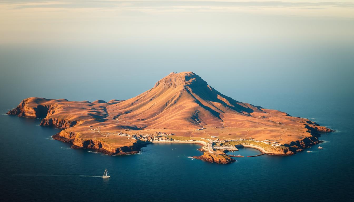
St. Helena is a British Overseas Territory in the South Atlantic. It’s about 16 by 8 kilometers and has a rich history and natural beauty.
Geographical Position and Basic Facts
St. Helena is over 1,800 kilometers west of Angola. The Portuguese found it in 1502. It has a population of 4,439 as of 2021.
The island’s terrain is rugged and volcanic. This has created unique landscapes. It’s also home to many endemic plants and animals.
Political Status as a British Overseas Territory
St. Helena is a British Overseas Territory. This means it’s governed by the UK. It has a stable government and keeps its cultural identity.
This status is also tied to Napoleon Bonaparte’s exile here. It’s a big part of the island’s history.
St. Helena Location: Exact Coordinates and Global Context
St. Helena is found in the South Atlantic Ocean. Its exact location shows it’s both isolated and strategic. Knowing where it is helps us understand its past and present importance.
Precise Geographical Coordinates
St. Helena’s exact spot is 15°55’24.3″S and 5°43’3.5″W. This places it in the vast South Atlantic. It’s one of the most distant islands with people living there. These coordinates are key for navigation and mapping.
Distance from Major Continents and Cities
St. Helena is about 1,600 km from West Africa. It’s far from big cities like Cape Town and Rio de Janeiro. For example, it’s 2,800 km from Cape Town and over 3,400 km from Rio de Janeiro.
Neighboring Islands and Territories
St. Helena is not alone; it’s part of a British Overseas Territory. This includes Ascension Island and Tristan da Cunha. Ascension Island is 1,300 km northwest, and Tristan da Cunha is over 2,400 km south. This shows St. Helena’s place in the region.
The island’s unique spot and history make it interesting to explore. Its remote location adds to its mystique and importance in world history.
Accessing Google Maps for St. Helena in2018
In 2018, getting to Google Maps for St. Helena was easy. It helped travelers move around the island with no trouble. Google Maps gave detailed maps and satellite views.
Google Maps Updates Specific to St. Helena
In 2018, Google Maps kept St. Helena up to date. It made sure the maps were right and fresh. This was key for a place like St. Helena, where changes could affect how you get around.
Some big updates for St. Helena on Google Maps in 2018 were:
- Better satellite images for a clearer view of the island.
- New roads and paths to show off recent changes.
- More places to see, like historical sites and natural spots.
Desktop vs. Mobile Experience for Remote Locations
Users could use Google Maps on desktop or mobile for St. Helena in 2018. Both were good, but they worked differently for places far away.
| Feature | Desktop Experience | Mobile Experience |
|---|---|---|
| Screen Size and Detail | Larger screens showed more details | Smaller screens were good for the basics |
| Navigation and Zooming | Mice made it easy to zoom and move around | Touchscreens were great for zooming and moving |
| Data Usage | No worries about data use | Watching data use was important, though |
Offline Maps Options for Travelers
Travelers to St. Helena found offline maps very helpful. Google Maps let users download maps for offline use. This was great when internet was scarce.
To get offline maps on Google Maps in 2018, follow these steps:
- Open Google Maps on your device.
- Search for St. Helena.
- Tap on the “Download” option.
- Pick the area you want to download.
Step-by-Step Guide to Finding St. Helena on Google Maps
To find St. Helena on Google Maps, you can search by name or use exact coordinates. This makes it easy for everyone to locate this island.
Search Techniques and Keywords
Searching for “St. Helena” in the Google Maps search bar will take you straight to the island. Adding keywords like “island” or “South Atlantic” helps avoid confusion with other places.
Using Coordinates for Precise Location
For a precise spot, use St. Helena’s coordinates: 15.95° S, 5.72° W. Typing these into Google Maps will take you right to the island.
Saving and Sharing St. Helena’s Location
Once you find St. Helena, you can save or share its location. Saving it makes it easy to find later. Sharing it lets you send the location to others. To do this, right-click on the island and choose the option you want.
| Method | Description | Use Case |
|---|---|---|
| Search by Name | Type “St. Helena” into Google Maps search bar | General search, easy to remember |
| Use Coordinates | Enter 15.95° S, 5.72° W into Google Maps | Precise location, avoiding confusion with other places |
| Save/Share Location | Right-click on St. Helena on the map | For future reference or sharing with others |
By following these steps, you can easily find and share St. Helena’s location on Google Maps. It’s a great tool for planning trips or researching this island.
Exploring St. Helena Through Google Maps Satellite View
Google Maps’ satellite imagery lets you see St. Helena Island in great detail. It’s perfect for learning about the island’s geography and finding important landmarks.
Key Landmarks Visible from Satellite
The satellite view on Google Maps shows major landmarks on St. Helena Island. You can see Longwood House, where Napoleon Bonaparte lived his last days. Jamestown, the capital, is also visible with its unique buildings and layout.
The high-quality satellite images let you see these places in detail. This is very helpful for those planning to visit.
Terrain Features and Topographical Highlights
St. Helena’s terrain is volcanic, with steep slopes and rough landscapes. The satellite view shows the island’s top features, like Diana’s Peak. It also highlights valleys and ridges.
This info is key for understanding the island’s ecosystem. It helps plan hikes or exploration trips.
Historical Significance of St. Helena Island
St. Helena Island is famous for its role in history, tied closely to Napoleon Bonaparte. Its remote spot in the South Atlantic made it a perfect, yet sad, home for the former French leader.
Napoleon Bonaparte’s Exile and Final Days
Napoleon Bonaparte was sent to St. Helena after losing at the Battle of Waterloo in 1815. He arrived on October 17, 1815, and stayed until his death on May 5, 1821. He lived in Longwood House, built just for him.
Despite strict rules, Napoleon’s stay on the island left a big mark on its history and culture.
The rules of his exile were strict, with British Governor Sir Hudson Lowe in charge. Napoleon’s health got worse, and he died from stomach cancer.
St. Helena’s Strategic Role in Maritime History
St. Helena was more than just Napoleon’s home. It was a key stop for ships going between Europe and Asia. It was a place to restock and fix ships during the age of sail.
The harbor, Jamestown, was a safe spot for ships. It showed the island’s lasting value, even as the world and trade changed.
Physical Geography and Natural Features
St. Helena has a landscape shaped by volcanoes. It has peaks, valleys, and coastlines. Its terrain was formed over millions of years from volcanic activity.
Volcanic Origin and Formation
St. Helena started forming about 14.5 million years ago. Its volcanic past is seen in its rugged terrain and volcanic cones. Lava flows built up the island’s landscape.
Mountain Peaks and Valleys
The island’s highest point is Diana’s Peak, at 818 meters. The peaks and valleys are covered in lush greenery. This creates a unique ecosystem.
Coastal Features and Beaches
St. Helena’s coast has rugged cliffs and rocky shores. Beaches like Sandy Bay and Prosperous Bay are surrounded by cliffs. The Atlantic Ocean shapes the coastline, making it dynamic.
St. Helena’s volcanic past, mountains, and coast make it special. Its natural features show its geological history and continue to evolve.
Climate and Weather Patterns of St. Helena
The island’s climate is shaped by the southeast trade winds, making it mild all year. This makes St. Helena a great spot for those looking for nice weather.
Seasonal Variations and Microclimates
St. Helena has a mild climate but it changes with the seasons. Temperatures range from 15°C to 28°C all year. The island also has different microclimates.
The central highlands are cooler and more humid than the coast. A climate expert said, “The microclimates of St. Helena are a result of its rugged terrain and the influence of the trade winds.”
“The variation in climate across the island creates a diverse range of ecosystems.”
Best Times to Visit Based on Weather
The best times to visit St. Helena are spring and autumn. April to June and September to November are the best months. The weather is comfortable, and there are fewer extreme weather conditions.
Transportation to St. Helena as of2018
Getting to St. Helena in 2018 was a big challenge. The island is far away, making it hard to reach. It’s located in the South Atlantic Ocean, far from most places.
Air Travel Options and Flight Routes
In 2018, St. Helena didn’t have a commercial airport. This made flying there hard. But, a new airport was being built. It was set to open soon.
Until the new airport opened, people had to take charter flights. Or they had to find other ways to get there.
| Air Travel Option | Description |
|---|---|
| Charter Flights | Specially arranged flights for travelers to and from St. Helena. |
| Private Aircraft | Privately owned aircraft could land at St. Helena with prior permission. |
Sea Travel and the RMS St. Helena’s Final Voyages
The RMS St. Helena was a key way to get to the island. It carried cargo and people. But, by 2018, it was not the only way.
The RMS St. Helena was special. It connected St. Helena to the UK and other places. But, its trips were changing. They eventually stopped with the start of air travel.
In 2018, traveling to St. Helena needed careful planning. The island’s distance was part of its beauty. But, it made getting there a bit tricky.
Navigating St. Helena Using Google Maps (2018)
Google Maps is a must-have for anyone visiting St. Helena. The island’s steep hills and remote areas make a good map essential. It helps travelers find their way around.
Road Network and Driving Directions
Google Maps shows St. Helena’s road network in detail. It helps users plan their routes easily. The main roads are well-mapped, giving driving directions for the island’s tough terrain.
Whether you’re going to Jamestown or exploring the island’s far corners, Google Maps keeps you on course.
Walking Routes and Hiking Trails
Google Maps also helps pedestrians and hikers. It highlights walking routes and hiking trails across the island. These paths lead to beautiful views and historical sites.
This feature is great for those who want to see St. Helena’s nature and history on foot.
Public Transportation Options
Google Maps also offers info on public transportation options on St. Helena. The island’s public transport is limited, but the service helps plan trips. As of 2018, the RMS St. Helena was a key transport link for people and goods.
Using Google Maps makes traveling to St. Helena easier. It’s perfect for driving, walking, or using public transport. The service’s detailed insights into the island’s geography and infrastructure are vital for visitors.
Major Settlements and Population Centers
St. Helena Island is home to several key settlements. These places are not just big in population. They also play big roles in the island’s economy and history.
Jamestown: The Capital and Main Port
Jamestown is the heart of St. Helena, being its main port. It’s famous for its historic buildings like Jacob’s Ladder and St. James’ Church. Jamestown is where you’ll find most shops, restaurants, and services.
Other Notable Settlements and Districts
Half Tree Hollow and Longwood are also important. Half Tree Hollow is very populated. Longwood is famous because Napoleon lived there during his exile. Here’s a quick look at these places:
| Settlement | Population | Notable Features |
|---|---|---|
| Jamestown | 714 | Main port, historic architecture |
| Half Tree Hollow | 984 | Residential area, community facilities |
| Longwood | 384 | Napoleon’s residence, historical significance |
Must-Visit Natural Attractions
St. Helena is a treasure trove of natural wonders. The island boasts a wide range of flora and fauna, some found only here. It’s a place where nature’s beauty shines brightly.
Endemic Flora and Fauna Locations
St. Helena is famous for its endemic species. You can see the St. Helena plover and the St. Helena giant earwig here. These unique creatures live in the endemic forests and protected areas. Exploring these spots lets you witness the island’s incredible biodiversity.
Diana’s Peak National Park
Diana’s Peak National Park is a gem on St. Helena. It’s the island’s highest point, with cloud forests and native plants. Hiking trails and panoramic views make it a top spot for nature lovers.
Coastal Viewpoints and Marine Areas
The coastline of St. Helena is stunning, with views of the Atlantic Ocean. You can also visit the Marine Reserve to see the marine life. It’s great for snorkeling, diving, or just enjoying the scenery.
Historical Sites and Cultural Landmarks
St. Helena is a mix of colonial and maritime history. It’s full of cultural and historical treasures. The island has many sites and landmarks that show its rich past.
Longwood House and Napoleon’s Tomb
Longwood House is a key site, where Napoleon Bonaparte lived in exile. Longwood House shows what life was like for Napoleon. Next to it is Napoleon’s Tomb, a big draw for tourists.
Colonial Fortifications and Buildings
St. Helena boasts colonial fortifications and buildings from the 17th century. Places like High Knoll Fort and Jamestown’s historic buildings show the island’s past. Visitors can learn a lot by exploring these sites.
Museums and Cultural Centers
The island has many museums and cultural centers. The St. Helena Museum is a must-visit. It tells the story of the island from its discovery to today. These places are key in keeping the island’s history alive.
| Historical Site | Description | Significance |
|---|---|---|
| Longwood House | Napoleon Bonaparte’s residence during exile | Historical significance related to Napoleon |
| Napoleon’s Tomb | Final resting place of Napoleon Bonaparte | Major tourist attraction |
| High Knoll Fort | Colonial fortification | Strategic military importance |
Practical Information for Visitors in2018
Planning a trip to St. Helena? Having the right info is key for a smooth visit. You’ll find many places to stay, eat, and shop. Plus, there are services for all your needs.
Accommodation Options and Locations
St. Helena has many places to stay, from cozy guesthouses to hotels. You can pick based on your budget and what you want to do. Most places are near Jamestown, the capital, making it easy to see the sights.
Dining and Shopping Facilities
The island’s food scene is a mix of local and international flavors. You can try fresh seafood, traditional British dishes, and more. For shopping, Jamestown has stores with souvenirs and essentials.
Essential Services and Emergency Information
St. Helena has the basics like medical care, banks, and post offices. Know where these are and what to do in an emergency. The island’s emergency system is reliable, so learn the local numbers and procedures.
Planning Your St. Helena Itinerary with Google Maps
Google Maps makes planning your trip to St. Helena easy. It helps you see the island’s sights, understand its layout, and plan your journey well.
Creating Custom Maps for Your Visit
Google Maps lets you make your own maps. For St. Helena, mark places like Longwood House, where Napoleon Bonaparte lived, or Diana’s Peak National Park. This way, you can plan your trip based on what you like and where things are.
Suggested Routes Based on Duration of Stay
Google Maps helps plan your trip based on how long you’ll stay. For a short trip, it suggests visiting Jamestown and nearby spots. For longer stays, it offers routes to see more of the island, including hard-to-reach places.
| Duration | Suggested Attractions |
|---|---|
| 3 Days | Jamestown, Longwood House |
| 7 Days | Diana’s Peak National Park, Napoleon’s Tomb, Coastal Walks |
Combining Attractions Efficiently
Google Maps helps you see the most of St. Helena by planning your route. It shows the best way to get from one place to another. This saves time and makes your trip better.
Using Google Maps for planning your trip to St. Helena ensures a great visit. You’ll see the island’s beauty and history.
Conclusion: Embracing the Unique Isolation of St. Helena
St. Helena Island is a hidden gem in the South Atlantic Ocean. Its remote spot offers a calm and enriching experience. Here, you can escape the daily rush and connect with nature and history.
Being a Remote Island, St. Helena is untouched. You can see volcanic landscapes, historic sites, and unique plants and animals. The island’s peace and preserved culture make it perfect for those wanting a real and quiet getaway.
On St. Helena, you can dive into its fascinating history, like Napoleon’s exile. You’ll also see the island’s stunning landscapes and special wildlife. Its isolation makes St. Helena a unique spot for those who love to explore new places.