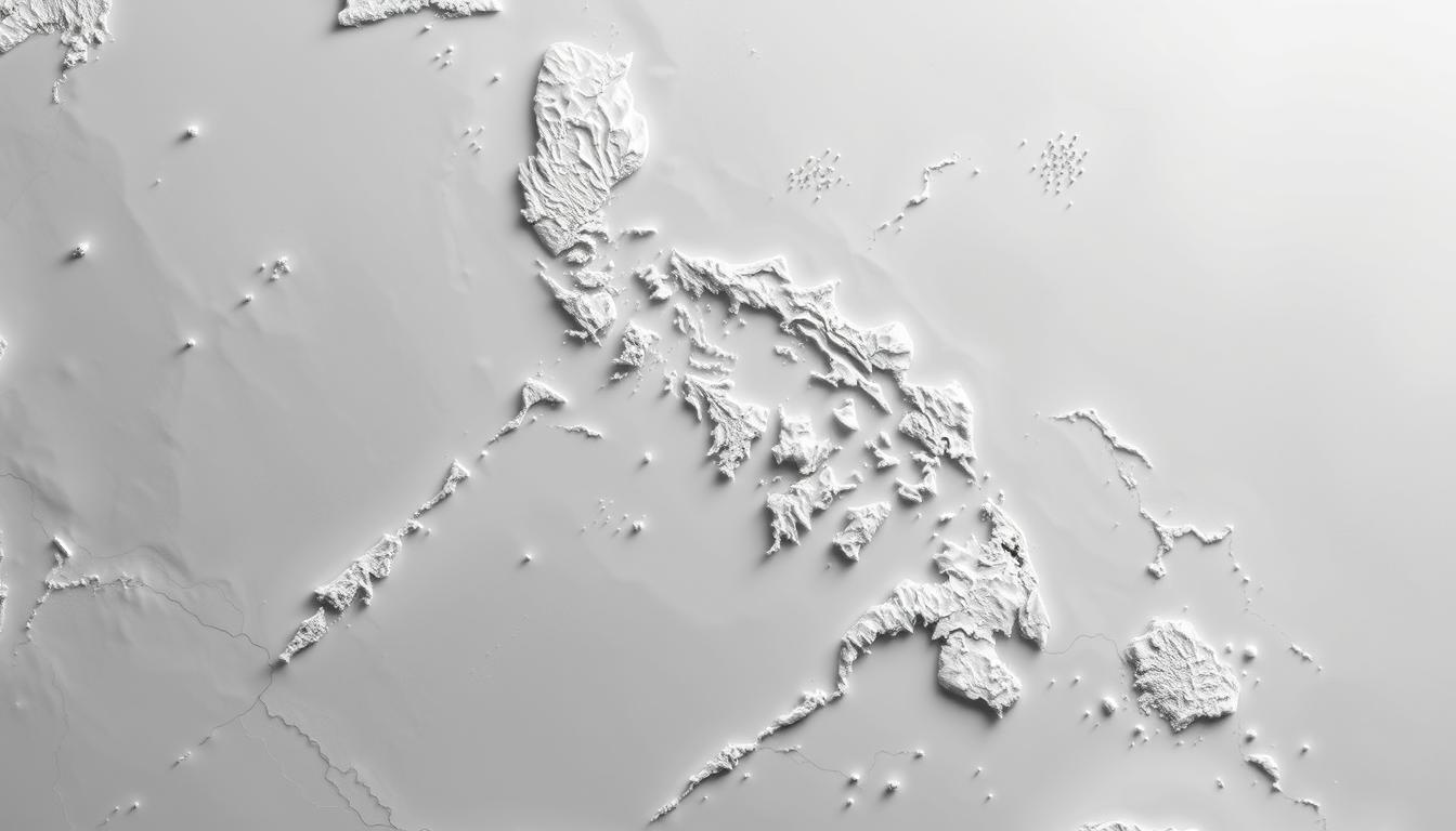
The geographical map of the Philippines shows over 7,000 islands in Southeast Asia. Knowing its layout is key to exploring its many regions and provinces.
The country is split into 18 regions. Eight are in Luzon, three in the Visayas, and six in Mindanao. This makes the Philippines important in both regional and global affairs, thanks to its Pacific location.
This article dives deep into the detailed map of the Philippines. It focuses on the locations of its regions and provinces. It also highlights the country’s geographical importance.
Understanding the Philippines Geographical Layout
The Philippines is an archipelago with over 7,000 islands. This unique layout affects its economy and culture. It has shaped the nation’s history and continues to influence its development.
Archipelagic Nature of the Philippines
The Philippines is an archipelago with more than 7,000 islands. This makes it one of the largest in the world. An interactive map of the Philippines shows how the islands are connected and where resources are found.
Major Island Groups: Luzon, Visayas, and Mindanao
The Philippines is divided into three main island groups: Luzon, Visayas, and Mindanao. Luzon is the largest and has the capital, Manila. A political map of the Philippines shows these divisions and their capitals.
The topographic map of the Philippines reveals the varied landscapes. From mountains to coastal plains, each island group is unique.
| Island Group | Number of Regions | Notable Features |
|---|---|---|
| Luzon | 8 | Home to Manila, the country’s capital |
| Visayas | 4 | Known for its beautiful beaches and islands |
| Mindanao | 6 | Rich in natural resources, including minerals and agricultural land |
Strategic Location in Southeast Asia
The Philippines is strategically located in Southeast Asia. It plays a key role in regional and global affairs. Its location near major shipping lanes boosts its economic and political importance.
“The Philippines’ unique geography has played a significant role in shaping its history and continues to influence its development trajectory.”
Evolution of Philippine Administrative Divisions
The Philippines has seen big changes in how it’s divided up. At first, it was split into provinces. These provinces were the main way the country was organized.
Historical Development of Regions
Regions were created to help with better governance. They started on September 24, 1972, with a law signed by President Ferdinand E. Marcos. This change made regions key in organizing provinces for easier management.
Transition from Provinces to Regions
Switching to regions was a smart move to make things more efficient. Provinces were grouped by where they were and their economy. This helped the government serve people better and manage resources well.
Current 17-Region Structure
Now, the Philippines is split into 17 regions. Each has its own special needs and features. Places like the National Capital Region (NCR), Cordillera Administrative Region (CAR), and Bangsamoro Autonomous Region in Muslim Mindanao (BARMM) are part of this setup. For those traveling or studying, knowing this is key. A road map Philippines helps find your way, and a satellite map Philippines gives detailed geography. A printable Philippines Map is great for planning and learning.
The changes in how the Philippines is divided show its efforts to better govern and meet its people’s needs. Knowing about these changes gives us a deeper look into the country’s politics and administration.
Philippines Map: Types and Uses for Different Purposes
The Philippines, with over 7,000 islands, uses many types of maps. These maps help us understand the country’s geography, how it’s divided, and how to navigate. There are maps for politics, topography, roads, and even satellite images.
Political Maps Showing Administrative Boundaries
Political maps show the Philippines’ divisions, like regions, provinces, cities, and towns. They are key for understanding the country’s governance. These maps are used in schools and government offices.
Topographic Maps Highlighting Terrain Features
Topographic maps show the Philippines’ land features, like mountains and valleys. They are crucial for studying geography, planning cities, and managing the environment. These maps help us see the country’s natural features and how they affect us.
Road Maps for Navigation
Road maps are essential for getting around. They show the country’s roads and help travelers, companies, and emergency services. These maps are great for planning trips and understanding traffic.
Satellite and Interactive Digital Maps
Digital technology has brought us satellite and interactive maps of the Philippines. These maps show the country’s geography in a detailed and dynamic way. Interactive maps are great for navigation, city planning, and disaster management.
In summary, the Philippines has many maps for different needs. From learning about the country to navigating it, maps are vital. Knowing about these maps helps us appreciate the Philippines’ rich geography.
Region I: Ilocos Region
The Ilocos Region is in northern Luzon. It’s full of cultural heritage and economic importance. The region is surrounded by the South China Sea to the west and the Cordillera Mountains to the east. This makes its landscape unique.
Geographical Location and Boundaries
The Ilocos Region, also known as Region I, is in northern Luzon. It borders the Cordillera Administrative Region to the east, the Cagayan Valley to the northeast, and the South China Sea to the west. Its location has made it historically and culturally significant.
Major Provinces and Cities
The region has four provinces: Ilocos Norte, Ilocos Sur, La Union, and Pangasinan. Major cities include Laoag, Vigan, and Dagupan. These cities are famous for their history, culture, and economy.
Cultural and Economic Significance
The Ilocos Region is known for its rich culture. Vigan, a UNESCO World Heritage Site, is a highlight. The region’s economy thrives on agriculture, fishing, and tourism. It also has a strong manufacturing sector, focusing on food processing and textiles.
| Province | Capital | Major Economic Activities |
|---|---|---|
| Ilocos Norte | Laoag | Agriculture, Tourism |
| Ilocos Sur | Vigan | Agriculture, Tourism, Manufacturing |
| La Union | San Fernando | Agriculture, Fishing, Tourism |
| Pangasinan | Lingayen | Agriculture, Fishing, Manufacturing |
Region II: Cagayan Valley
The Cagayan Valley region is in northern Luzon. It’s key to the Philippines’ farming. Its soil is fertile, and it has many rivers, perfect for farming.
Geographical Features and River Systems
Cagayan Valley has wide plains and big rivers. The Cagayan River is one of the longest in the country. This makes it great for farming.
Component Provinces
The region has five provinces: Batanes, Cagayan, Isabela, Nueva Vizcaya, and Quirino. Each province adds to the region’s farming and has its own culture.
Agricultural Importance
Cagayan Valley is called the “Rice Granary” of the Philippines. It grows a lot of rice, corn, and tobacco. Its farming helps feed the country.
Using a road map Philippines or a satellite map Philippines helps understand the region. It’s useful for planning and navigating.
Region III: Central Luzon
Central Luzon is a key region, close to Metro Manila, the capital. Its closeness to the capital highlights its role in the country’s economy and industry.
Strategic Position Near Metro Manila
Being near Metro Manila, Central Luzon is perfect for businesses and industries. Its good roads and transport links make it easy to get to the capital. This draws investors to the area.
Industrial and Economic Centers
The region has important industrial and economic centers, like the Clark Freeport Zone. This zone has brought in a lot of investment. It has helped the region grow economically.
Historical Significance
Central Luzon is also rich in history and culture. It has many historical sites and landmarks, like the Barasoain Church. This church is a big historical spot in the Philippines.
For those traveling or investing, a printable Philippines Map is very useful. It shows the layout and key places in Central Luzon. Knowing the geographical map of the Philippines helps in exploring the region and finding opportunities.
| Province | Capital | Economic Activity |
|---|---|---|
| Aurora | Baler | Agriculture, Tourism |
| Bataan | Balanga | Industry, Tourism |
| Bulacan | Malolos | Industry, Agriculture |
Region IV-A: CALABARZON
CALABARZON is a key region in the Philippines, known for its rich natural resources and strategic location. It includes the provinces of Cavite, Laguna, Batangas, Rizal, and Quezon. This region is one of the most populous in the country.
Proximity to the National Capital Region
CALABARZON is close to Metro Manila, the National Capital Region. This makes it a great place for businesses and industries. It’s easy to get to major transportation hubs, boosting the region’s connection to markets worldwide.
Industrial and Manufacturing Hub
The region is a major industrial and manufacturing hub. Many industries have set up in its economic zones. These industries help the local economy and create jobs for residents.
An interactive map of the Philippines shows where these industrial areas are. It helps see how close they are to cities and transport networks.
Tourist Destinations and Natural Resources
CALABARZON is famous for its tourist destinations and natural beauty. It has beautiful beaches, mountains, and more. For example, Batangas’ beaches and Quezon’s mountains are very popular.
A topographic map of the Philippines is great for seeing the region’s varied landscapes. It shows the coastal areas and mountains, highlighting its beauty and eco-tourism possibilities.
Region IV-B: MIMAROPA
MIMAROPA, or Region IV-B, is a unique area in the Philippines. It includes island provinces like Palawan and Mindoro. This region has its own geography, with both benefits and hurdles.
Island Provinces and Geographical Challenges
The MIMAROPA region has five provinces: Occidental Mindoro, Oriental Mindoro, Marinduque, Romblon, and Palawan. These islands have beaches, mountains, and forests. But, their island setting makes it hard to connect and face natural disasters.
Tourism and Marine Resources
MIMAROPA is full of natural wonders, perfect for tourism. Palawan has the famous Underground River, a UNESCO site. The area’s seas are also rich, with great dive spots and biodiversity. A satellite map of the Philippines helps spot these spots.
Cultural Diversity
MIMAROPA’s culture is as varied as its landscapes. It has many indigenous groups, each with their own traditions. This diversity makes it a great place for cultural tours. A geographical map of the Philippines shows where these cultures live.
In summary, MIMAROPA is key for both geography and culture. Its islands offer tourism and economic chances but also face challenges.
Region V: Bicol Region
The Bicol Region is in southern Luzon, showing the Philippines’ varied landscapes. It’s famous for its volcanoes and natural wonders. These draw tourists and boost the local economy.
Volcanic Landscapes and Natural Features
Mayon Volcano, a symbol of the Philippines, is here. Its perfect shape draws many visitors. The area’s volcanoes are due to its spot on the Pacific Ring of Fire.
Provincial Composition
The Bicol Region has six provinces: Albay, Camarines Norte, Camarines Sur, Catanduanes, Masbate, and Sorsogon. Each province has its own culture and economy.
Cultural Identity and Economic Activities
The region’s culture comes from its history and geography. Bicolanos are known for their strength and cleverness. The economy mainly comes from farming, fishing, and tourism.
| Province | Capital | Main Economic Activity |
|---|---|---|
| Albay | Legazpi | Agriculture, Tourism |
| Camarines Sur | Naga | Agriculture, Fishing |
| Sorsogon | Sorsogon City | Agriculture, Tourism |
Knowing the Bicol Region’s geography and culture is key. It helps when using a political map of the Philippines or a road map Philippines.
Region VI: Western Visayas
The Western Visayas region is full of cultural and natural wonders. It’s a key part of the Philippines’ identity. It includes major islands like Panay and Negros, and six provinces: Aklan, Antique, Capiz, Guimaras, Iloilo, and Negros Occidental.
Major Islands and Provinces
Western Visayas is known for its big islands and provinces. Each province has its own unique geography and culture.
| Province | Capital | Notable Features |
|---|---|---|
| Aklan | Kalibo | Boracay Island, known for its white sand beaches |
| Iloilo | Iloilo City | Rich cultural heritage, historic churches, and vibrant festivals |
| Negros Occidental | Bacolod | Known for its sugar industry and MassKara Festival |
Economic Activities and Resources
The region boosts the Philippine economy with agriculture, tourism, and industry. A detailed map of the Philippines shows Western Visayas’ strategic location and growth opportunities.
Cultural Heritage
Western Visayas has a rich cultural heritage. It’s shaped by its history and traditions. The region’s festivals and historic sites are fascinating to explore on an interactive map Philippines.
Region VII: Central Visayas
Central Visayas is known for its vibrant culture and stunning landscapes. It’s a key part of the Philippines. The region has four provinces, including Cebu and Bohol, famous for their attractions and economic value.
Urban Centers and Tourism Hotspots
Cebu City is a major hub for business and tourism in Central Visayas. It’s also home to famous spots like Bohol’s Chocolate Hills. These hills are a unique geological wonder that draws visitors from all over.
Island Provinces
The island provinces of Cebu and Bohol offer a mix of landscapes and cultural experiences. These islands are known for their natural beauty and rich history and culture.
Economic Significance
Central Visayas is vital to the Philippine economy. It’s driven by tourism, manufacturing, and its strategic location. Using satellite maps and topographic maps helps understand the region’s geography. This aids in planning economic activities.
Region VIII: Eastern Visayas
Eastern Visayas, with six provinces, has faced many natural disasters. This has led to efforts to be resilient and recover. The region’s location makes it vulnerable to typhoons and other disasters.
Geographical Vulnerability to Typhoons
Eastern Visayas is in a typhoon-prone area. It’s located in the eastern part of the Philippines. This means it needs strong disaster plans and responses.
Provincial Composition
The region has six provinces: Biliran, Eastern Samar, Leyte, Northern Samar, Samar, and Southern Leyte. Each province has its own culture and economy.
Recovery and Development
After natural disasters, Eastern Visayas has worked hard to recover and develop. These efforts aim to make the region more resilient and support sustainable growth.
| Province | Capital | Major Economic Activity |
|---|---|---|
| Biliran | Naval | Agriculture |
| Eastern Samar | Borongan | Fishing |
| Leyte | Tacloban | Commerce |
The region’s recovery shows the strength of its people and the success of development efforts.
Regions IX to XIII: Mindanao Regions
Mindanao, the southernmost major island group of the Philippines, is divided into five distinct regions. Each region has its own unique characteristics. These regions play a big role in the country’s economy and cultural diversity.
Region IX: Zamboanga Peninsula
The Zamboanga Peninsula, also known as Region IX, is a key area in Mindanao. It boasts a rich cultural heritage and is economically active in agriculture and fishing. Zamboanga City, the capital, is a major urban center in Mindanao.
Economic Activities: The region’s economy thrives on agriculture, with crops like rice, corn, and coconut being major contributors. Fishing is also a big industry, thanks to the region’s abundant marine resources.
Region X: Northern Mindanao
Northern Mindanao, or Region X, is a vital region in Mindanao. It has five provinces and is known for its industrial and agricultural activities. Cagayan de Oro, the capital, is a major economic hub.
Industrial Significance: The region is home to various industries, including manufacturing, agriculture, and mining. Its strategic location makes it a key center for trade and commerce.
Region XI: Davao Region
The Davao Region, or Region XI, is a major economic driver in Mindanao. It is famous for its agricultural production, including coconut, banana, and other crops. Davao City, the capital, is a major urban center.
Agricultural Production: The region is one of the country’s top producers of various agricultural products. Its fertile soil and favorable climate make it perfect for farming.
Region XII: SOCCSKSARGEN
SOCCSKSARGEN, or Region XII, is a region rich in natural resources. It is known for its agricultural production, including rice, corn, and coconut. The region is also home to various industries, including mining and manufacturing.
Natural Resources: The region is endowed with significant natural resources, including mineral deposits and fertile agricultural land. Its diverse economy contributes to the country’s overall development.
Region XIII: Caraga
Caraga, or Region XIII, is the northeasternmost region of Mindanao. It is known for its rich mineral resources and agricultural activities. Butuan City is the region’s capital.
Mineral Resources: The region is rich in mineral deposits, including gold, nickel, and other minerals. Its mining industry is a significant contributor to the local economy.
The five regions of Mindanao are interconnected through their economic and cultural activities. Understanding these regions is key to appreciating the diversity and complexity of the Philippines as a whole.
Special Regions: NCR, CAR, and BARMM
The Philippines has special regions like the National Capital Region, Cordillera Administrative Region, and Bangsamoro Autonomous Region. Each plays a key role in the country’s culture, economy, and politics.
National Capital Region (Metro Manila)
Metro Manila is the heart of the Philippines. It’s where the government and big companies are. It’s vital for the country’s growth.
Metro Manila’s importance goes beyond politics. It’s also a hub for learning, health, and fun.
Cordillera Administrative Region
The Cordillera Administrative Region is rich in culture and home to many indigenous people. Its mountains keep their traditions alive.
The Cordillera region’s unique culture is a big part of the Philippines. It’s key for keeping traditions alive and for tourism.
Bangsamoro Autonomous Region in Muslim Mindanao
The Bangsamoro Autonomous Region in Muslim Mindanao (BARMM) has a lot of freedom. It was made to meet the needs of Muslims in Mindanao.
BARMM’s freedom helps it manage its own affairs. This promotes peace and growth in the area.
Special Administrative Status
NCR, CAR, and BARMM have special statuses. They have more freedom to handle their own affairs. This ensures their unique needs are met.
“The creation of these special regions shows the Philippines’ commitment to diversity. It promotes regional growth and makes sure governance meets local needs.”
Knowing about these special regions helps us understand the Philippines better. The political map of the Philippines and geographical map of the Philippines are great for seeing the country’s varied regions and their setups.
Practical Guide to Using Philippines Maps for Travelers
Travelers to the Philippines can greatly benefit from understanding how to use maps effectively. The country’s archipelagic nature, with over 7,000 islands, demands a practical approach to navigation. Knowing the different types of maps and how to use them can make travel better.
Navigation Between Regions and Islands
Navigating the Philippines’ regions and islands requires a good grasp of the country’s geography. Travelers can use road maps to navigate within islands. They can also use interactive maps to plan their journey across different regions.
Understanding Transportation Networks
The Philippines has a wide transportation network, including roads, airports, and seaports. Travelers can use satellite maps to see the layout of these networks. This helps in planning efficient routes.
| Transportation Mode | Key Features | Usefulness for Travelers |
|---|---|---|
| Roads | Extensive network connecting major cities and towns | High |
| Airports | Multiple international and domestic airports | High |
| Seaports | Major seaports for domestic and international travel | Medium |
Digital Map Resources and Applications
There are many digital map resources and apps to help travelers in the Philippines. These include online interactive maps and mobile apps. They provide real-time info on traffic, weather, and more.
Regional Travel Considerations
Travelers should also consider regional travel factors. This includes weather patterns, cultural events, and local customs. Knowing these can help plan a more enjoyable and respectful trip.
Conclusion: The Diverse Tapestry of the Philippine Archipelago
The Philippines is a country full of geographical and cultural diversity. It has a complex archipelago with a rich cultural heritage and natural resources. Knowing its regions and provinces helps us appreciate its complexity and richness.
Looking at the Philippines Map shows the country’s unique layout. Its major island groups, like Luzon, Visayas, and Mindanao, shape the nation’s identity. The map also shows the Philippines’ strategic location in Southeast Asia, making it key for trade and commerce.
Exploring the Philippines’ regions, from Ilocos to Bangsamoro Autonomous Region in Muslim Mindanao, deepens our understanding. A detailed map of the Philippines is vital for navigating its complex geography. It helps us discover its many hidden gems.