The Republic of Malawi is a landlocked country in southeastern Africa. It is bordered by Tanzania, Zambia, and Mozambique. The Great Rift Valley runs through it, making its geography diverse.
Malawi’s geography is shaped by the Great Rift Valley. This has given it many major lakes and rivers. These water bodies are key to its economy and culture.
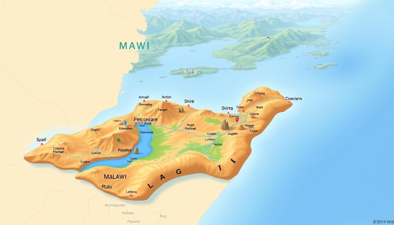
The country’s varied landscape is a big part of its identity. This makes the Malawi Map very important. It helps us understand its layout and features.
Malawi’s major lakes, rivers, and cities are vital. They support its ecological and economic systems.
Geographical Overview of Malawi
Malawi is located in Southeastern Africa. It has highlands, valleys, and big water bodies. It’s a landlocked country, bordered by Tanzania, Zambia, and Mozambique.
Location and Size
Malawi is in a key spot in Southeastern Africa. It covers about 118,484 square kilometers.
Position in Africa
Malawi sits in the southeastern part of Africa. This area is known for its varied landscapes. Its location brings together different cultures and geography.
Land Area and Borders
Malawi has a total area of 118,484 square kilometers. It shares borders with Tanzania, Zambia, and Mozambique. These borders mix natural and man-made lines.
Topographical Features
The Great Rift Valley shapes Malawi’s landscape. It creates different landscapes and geological features.
Great Rift Valley
The Great Rift Valley greatly influences Malawi. It affects the climate, economy, and culture. It’s known for deep lakes, valleys, and mountains.
Diverse Landscapes
Malawi has varied landscapes, from mountains to deep valleys and lakes. This variety supports many ecosystems and biodiversity.
Malawi’s geography is beautiful and vital to its economy and culture. The different landscapes help with agriculture, tourism, and more.
Understanding the Malawi Map: Key Features
To understand the Malawi map, we need to look at its key features. These include political and natural boundaries. The country’s geography is diverse, with various administrative divisions and natural features. These features shape its identity.
Political and Administrative Divisions
Malawi is divided into several districts and regions. Each has its own administrative center. The political map shows these divisions, which are important for administration.
Districts and Regions
The districts in Malawi are grouped into regions for easier administration. There are three main regions: the Northern Region, the Central Region, and the Southern Region.
Major Boundaries
The major boundaries of Malawi are its political borders with neighboring countries. These boundaries are key to understanding the country’s geopolitical context.
Natural Boundaries
Malawi’s natural boundaries include its lake shores and mountain ranges. These boundaries greatly influence its climate and geography.
Lake Shores
The shores of Lake Malawi and other lakes are a big part of Malawi’s natural boundaries. These shores are important for geography, economy, and ecology.
Mountain Ranges as Borders
Mountain ranges, like the Nyika Plateau, act as natural borders. They add to the country’s diverse topography. These ranges also affect the local climate and ecosystems.
Lake Malawi: The Jewel of East Africa
Lake Malawi is the third-largest lake in Africa. It’s known for its size and the life it supports. The lake is key to Malawi’s geography, home to a wide variety of life and important for the local economy.
Size and Characteristics
Lake Malawi is big and unique. It’s about 580 kilometers long and 75 kilometers wide. It covers an area of around 29,600 square kilometers.
Depth and Volume
The lake is very deep, reaching up to 700 meters. It holds about 8,400 cubic kilometers of water. This is a big part of the world’s freshwater.
Shoreline Features
The lake’s shoreline is varied. You’ll find sandy beaches, rocky shores, and scenic bays. These features support many different habitats for aquatic life.
Ecological Significance
Lake Malawi is known for its diverse life. Its clear waters and different habitats support many species. Many of these species are found nowhere else in the world.
Endemic Fish Species
The lake is famous for its fish. It has over 1,000 species, with many being found only here. This makes the lake very important for its biodiversity.
Lake Malawi National Park
The Lake Malawi National Park is at the lake’s southern end. It’s a UNESCO World Heritage Site. The park protects the lake’s shoreline and surrounding areas, keeping the natural beauty and biodiversity safe.
Economic Importance
Lake Malawi is not just a treasure for nature. It’s also very important for Malawi’s economy. The lake supports fishing and tourism, which are key to the country’s economy.
Fishing Industry
The fishing industry is big here. The lake is a rich source of fish and other aquatic products. It helps many local communities make a living.
Tourism
Tourism is also a big deal. The lake’s beauty, wildlife, and activities attract tourists. This helps the local and national economy a lot.
Key Facts about Lake Malawi:
- Third-largest lake in Africa
- Maximum depth of approximately 700 meters
- Over 1,000 species of fish, many endemic to the region
- Supports significant fishing and tourism industries
- Part of the Lake Malawi National Park, a UNESCO World Heritage Site
Other Major Lakes in Malawi
Malawi is home to many lakes, like Lake Chilwa, Lake Malombe, and Lake Chiuta. These lakes are key to the local environment and economy. They are not as famous as Lake Malawi but are vital for the ecosystem and support various economic activities.
Lake Chilwa
Lake Chilwa is a wetland in southeastern Malawi. It’s known for its biodiversity and economic value. Many communities around the lake depend on it for their livelihood.
Seasonal Fluctuations
The water level in Lake Chilwa changes with the seasons. This affects the ecosystem and the people who live nearby. “The changing water levels bring both challenges and opportunities for the local population,” say environmental experts.
Economic Value
Lake Chilwa is vital for the local economy. It supports fishing, agriculture, and other livelihood activities. The lake’s value goes beyond fishing, as it also boosts tourism and provides ecosystem services.
Lake Malombe
Lake Malombe is another key lake in Malawi. It’s connected to Lake Malawi through the Shire River. This connection has big ecological and economic benefits.
Connection to Lake Malawi
The Shire River links Lake Malombe to Lake Malawi. This facilitates the exchange of water and aquatic life between the two lakes. This connection is essential for the ecological balance of the area.
Fishing Communities
Lake Malombe supports fishing communities. These communities earn a living and get food from fishing. The fishing industry around Lake Malombe is a big part of the local economy.
Lake Chiuta
Lake Chiuta is a smaller but important lake in southeastern Malawi. It’s known for being shared with Mozambique.
Transboundary Nature
The lake’s shared nature means cooperative management is needed between Malawi and Mozambique. This ensures the lake’s ecological integrity and sustainable use.
Ecological Importance
Lake Chiuta is vital for its ecological importance. It supports a wide range of flora and fauna. Conservation efforts are needed to protect this valuable ecosystem.
Principal Rivers of Malawi
Malawi’s geography is shaped by several key rivers. These rivers are essential for the country’s ecosystem and economy. The Shire, Ruo, and Bua rivers support agriculture, hydroelectric power, and biodiversity.
Shire River
The Shire River is a major waterway in Malawi. It flows from Lake Malawi into the Zambezi River. It’s about 402 kilometers long and a key source of hydroelectric power.
Course and Flow
The Shire River starts at Lake Malawi’s southern end and flows south. It has both slow and fast sections, perfect for hydroelectric power.
Hydroelectric Power
The Shire River is used for hydroelectric power through dams like Nkula Falls and Tedzani Dam. These dams are vital for Malawi’s energy, providing a lot of electricity.
“The Shire River is the backbone of Malawi’s energy infrastructure, supporting both the economy and the daily lives of its people.”
Ruo River
The Ruo River is a significant river in Malawi. It’s known for its watershed and tributaries. It’s vital for the regional ecosystem.
Watershed and Tributaries
The Ruo River’s watershed is large, with many tributaries. This network supports a wide range of plants and animals.
Flooding Patterns
The Ruo River experiences seasonal flooding. This can have both good and bad effects on the environment and communities.
Bua River
The Bua River is important for Malawi, supporting agriculture and ecosystems.
Agricultural Importance
The Bua River is key for irrigation. It helps agriculture in the area, boosting Malawi’s food security and economy.
Conservation Efforts
There are efforts to protect the Bua River and its ecosystems. These aim to preserve biodiversity and ensure the river’s resources last long.
In conclusion, Malawi’s main rivers are key for the country’s ecological balance and economic growth. Managing these water resources is vital for Malawi’s future.
Major Cities and Urban Centers
Malawi’s cities are key to its economy and government. They are big in population and drive the country’s growth.
Lilongwe: The Capital City
Lilongwe is Malawi’s capital and a center of government. It has many government offices.
Urban Layout and Districts
The city has different districts, each with its own feel. It blends modern and traditional designs.
Administrative Functions
Lilongwe is where government decisions are made. It’s home to many government agencies.
Blantyre: The Commercial Hub
Blantyre is Malawi’s business center. It’s important for the economy and has a rich history.
Industrial Significance
Blantyre has many industries. These help a lot with Malawi’s economy.
Historical Development
Blantyre is one of Malawi’s oldest cities. Its growth shows the country’s progress.
Mzuzu and Other Urban Centers
Other cities like Mzuzu add to Malawi’s urban life. Mzuzu is a big city in the north.
Zomba: The Former Capital
Zomba was once the capital. It’s now a cultural and educational center.
Emerging Urban Areas
New cities are also growing. They are becoming important for business and people.
Regional Geography of Malawi
Malawi is divided into three main regions: Northern, Central, and Southern. Each has its own geography, economy, and people. This diversity makes Malawi’s landscape and economy rich and varied.
Northern Region
The Northern Region is known for its rugged terrain and natural beauty. It has many important geographical features.
Distinctive Features
The region is home to the Viphya Mountains and is near the Lake Malawi shoreline. These features create stunning landscapes and diverse ecosystems.
Major Settlements
Mzuzu is the biggest city in the Northern Region. It’s a key commercial and administrative center. Other important places include Karonga and Chitipa, each with its own culture and economy.
Central Region
The Central Region is Malawi’s agricultural heart. It has fertile land and a good climate for farming.
Agricultural Heartland
This area is famous for growing tobacco, tea, and other crops. It’s vital for Malawi’s farming economy.
Population Distribution
The Central Region is very populated. Lilongwe, the capital, is a big city. The area has both rural and urban people, with many involved in farming.
Southern Region
The Southern Region is a key economic area. It has a diverse economy and important geographical features.
Economic Activities
The region is involved in agriculture, mining, and tourism. Blantyre, the commercial capital, shows the region’s economic role.
Geographical Challenges
The Southern Region has challenges like the Shire Highlands‘ rugged terrain and the Shire River‘s low-lying areas. These can lead to flooding.
Climate and Weather Patterns of Malawi
Malawi’s climate varies a lot, with changes in seasons and different areas having their own weather. The country’s lakes and highlands play a big role in these changes. This leads to many different weather conditions across Malawi.
Seasonal Variations
Malawi has two main seasons: rainy and dry. Each season has its own unique weather patterns.
Rainy Season Characteristics
The rainy season in Malawi is from November to April. It’s when most of the country’s rain falls, with heavy downpours in some spots. This season is key for farming, as it gives crops the water they need.
Dry Season Patterns
The dry season runs from May to October. It’s known for dry and cooler temperatures. Rainfall drops a lot, making many areas dry.
Regional Climate Differences
Malawi’s climate varies by region, thanks to Lake Malawi and the highlands. These factors change how hot or cold it is and how much rain falls in different places.
Lake Effect on Climate
Lake Malawi helps keep the weather around it stable. It makes temperatures more even than inland areas. The lake also affects rain, with some places getting more because of it.
Highland Climate Zones
The highlands of Malawi have a cooler climate. They can get more rain too. These areas are milder than the lower lands, making them good for farming and living.
Malawi’s Topography and Elevation
Malawi’s landscape is filled with mountains, plateaus, and valleys. These features add to its biodiversity. The elevation changes create diverse ecosystems.
Mountain Ranges
Malawi boasts several mountain ranges, with the Mulanje Massif being the most famous. The Mulanje Massif is a key geographical feature and a biodiversity hotspot.
Mulanje Massif
The Mulanje Massif is Malawi’s highest peak, over 3,000 meters high. It’s home to unique plants and animals, some found nowhere else.
Zomba Plateau
The Zomba Plateau is known for its tea and stunning views. It attracts both locals and tourists.
Plateaus and Valleys
Malawi also has vast plateaus and deep valleys. The Shire Highlands and Nyika Plateau stand out among these.
Shire Highlands
The Shire Highlands are fertile and vital for farming. Their elevation makes the climate cooler, perfect for many crops.
Nyika Plateau
The Nyika Plateau in northern Malawi is vast and elevated. It’s known for its biodiversity and unique landscapes. It’s a favorite spot for hiking and nature tours.
Malawi’s varied landscape supports many ecosystems, from forests to grasslands. Knowing about its topography helps us appreciate its beauty and manage its resources well.
Transportation Infrastructure on the Malawi Map
Malawi’s transportation network is key to its economy and society. It helps move goods and people around the country and abroad.
Major Highways and Roads
Malawi’s roads are its main transport system. The country is working to improve these roads to boost trade and travel.
North-South Corridor
The North-South Corridor is a major route in Malawi. It connects the country to its neighbors, making trade and economic ties stronger.
International Connections
Malawi’s roads also link it to the world. This global connection is vital for the country’s growth.
| Highway/Road | Description | Importance |
|---|---|---|
| North-South Corridor | Connects northern and southern parts of Malawi | Facilitates regional trade |
| M1 Road | Links Lilongwe to Blantyre | Major commercial route |
| M6 Road | Connects to neighboring countries | Enhances international trade |
Railways and Airports
Malawi also has railways and airports. These are important for moving goods and people.
Rail Network
Malawi’s rail system links it to other countries. It’s a key part of the country’s transport network.
Air Transportation Hubs
Malawi has several airports, with Lilongwe International Airport being a major one. Air travel helps move people and goods within and outside the country.
Malawi’s transport system is essential for its growth. Investing in this area is important for better connectivity and trade.
Cultural Geography and Ethnic Distribution
Malawi’s culture is rich and diverse, thanks to its many ethnic groups. The Chewa, Nyanja, Tumbuka, and others have shaped the nation’s identity. Each group adds to Malawi’s cultural heritage.
Major Ethnic Groups
Malawi has several major ethnic groups, each with its own culture. The Chewa and Nyanja are key, making big contributions to the country’s culture.
Chewa and Nyanja
The Chewa and Nyanja live mainly in central and southern Malawi. They are known for their farming and rich cultural traditions. Their language, music, and dance are unique.
Tumbuka and Northern Peoples
The Tumbuka people live in northern Malawi. They have their own language and cultural practices. These are important to Malawi’s cultural diversity.
Cultural Landscapes
Malawi’s cultural landscapes are shaped by traditional settlements and cultural sites. These landscapes are important to locals and help define Malawi’s identity.
Traditional Settlements
Malawi’s traditional settlements have unique styles and communal living. They help keep cultural heritage and traditions alive.
Cultural Heritage Sites
Malawi has many cultural heritage sites, like historical villages and sacred sites. These sites are key to understanding Malawi’s history and cultural growth.
Tourism Destinations on the Malawi Map
Malawi is a top spot for tourists looking for a memorable trip. It boasts stunning landscapes and a lively culture. The country’s varied geography, with lakes, rivers, and parks, has lots to do and see.
Lake Malawi Attractions
Lake Malawi is a major draw, famous for its clear waters and beautiful beaches. The lake’s edge is perfect for relaxing and trying water sports.
Beach Resorts
The beach resorts along Lake Malawi offer luxury stays and fun activities. You can snorkel, dive, or take a boat tour. Enjoy the calm setting and amazing views.
Island Destinations
Malawi has islands like Likoma and Chisumulu on Lake Malawi. They’re great for quiet breaks and discovering local culture and sea life.
Wildlife and Nature Reserves
Malawi is also famous for its wildlife and nature reserves. These places are full of different plants and animals.
Liwonde National Park
Liwonde National Park is known for its diverse wildlife. You can go on boat tours along the Shire River. See hippos, crocodiles, and birds.
Nyika National Park
Nyika National Park is in northern Malawi. It has hills, grasslands, and many animals like leopards and zebras. It’s perfect for hiking and exploring nature.
Malawi’s tourism thrives thanks to its varied landscapes and culture. It’s a great place for anyone interested in nature or culture. Malawi has something for everyone.
Conclusion
Malawi’s diverse geography is key to its economy, culture, and nature. The Malawi Map shows the country’s lakes, rivers, and cities. These are vital for understanding its growth.
Lake Malawi is a major freshwater source and a tourism and fishing hotspot. The Shire River supports farming and hydroelectric power.
Lilongwe, Blantyre, and Mzuzu are major cities that boost Malawi’s economy and culture. Knowing Malawi’s geography helps us understand its identity and challenges.
In summary, the Malawi Map and geography are closely linked. They shape Malawi’s progress and future. Recognizing these features helps us grasp Malawi’s development complexities.