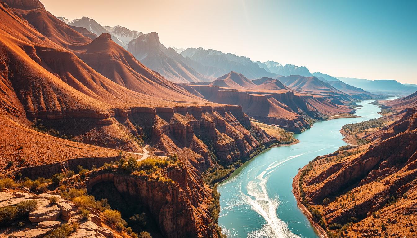
The Rio Grande River is a vital source for seven U.S. and Mexican states. It flows through dry lands. Starting in south-central Colorado, it heads towards the Gulf of Mexico.
This water source is key for many ecosystems and communities. It’s essential for farming, wildlife, and drinking water.
Knowing the Rio Grande River’s path and role is important. As we look at the Southwestern US Map, we’ll see its features and how it shapes the area.
The Southwestern United States: A Geographical Overview
The Southwestern US covers many states, each with its own unique features. Arizona, New Mexico, Texas, and parts of Colorado, Utah, Nevada, and California make up this area. It’s known for its deserts, mountains, and rivers.
Defining the Southwestern Region
The Southwestern United States is known for its dry deserts and tough terrain. Arizona and New Mexico are at the center of this area. Texas and parts of Colorado, Utah, Nevada, and California are also part of it. They share cultural and geographical ties with the region.
Key Geographical Features
The Southwest has some of the most famous landscapes in the US. You’ll find the Grand Canyon in Arizona, the Rocky Mountains in Colorado, and the Rio Grande along the US-Mexico border.
| State | Notable Geographical Features |
|---|---|
| Arizona | Grand Canyon, Sonoran Desert |
| New Mexico | White Sands National Park, Rio Grande Gorge |
| Texas | Big Bend National Park, Guadalupe Mountains |
The Rio Grande: Lifeline of the Southwest
The Rio Grande River starts in the San Juan Mountains. It then flows through the Southwest, supporting agriculture, cities, and ecosystems. This river is vital for the region.
Origin in the San Juan Mountains
The Rio Grande River begins in the San Juan Mountains of Colorado. It travels about 1,885 miles to the Gulf of Mexico. This mountainous start is key to its role in the Southwest.
Major Tributaries and Watershed
The Rio Grande has big tributaries like the Pecos, Devils, Chama, and Conchos rivers. These rivers add a lot to the river’s flow and help its ecosystems.
| Tributary | Contribution |
|---|---|
| Pecos River | Significant water source |
| Devils River | Enhances water quality |
| Chama River | Supports local agriculture |
| Conchos River | Major contributor to Rio Grande’s flow |
The River’s Path to the Gulf of Mexico
The Rio Grande flows from Colorado through New Mexico and Texas to the Gulf of Mexico. It marks the border between the U.S. and Mexico. This makes it important for both countries and the environment.
“The Rio Grande is not just a river; it’s a lifeline that sustains the Southwest’s natural beauty and economic vitality.”
The Rio Grande’s journey shows its big role in the Southwestern United States. It’s a key part of the region’s geography and ecology.
Comprehensive Southwestern US Map Guide
Exploring the Southwestern United States needs a detailed map guide. A detailed Southwest US map is key for understanding the area’s varied landscapes and water bodies like the Rio Grande.
Essential Elements of Regional Maps
A good map of the Southwest US should have several important parts:
- State boundaries and major cities
- Rivers and significant water bodies
- Topographical features such as mountains and canyons
- Major highways and transportation routes
These elements help you grasp the region’s layout and plan your trips or studies.
Reading Topographical Features
Understanding a Southwestern US topographic map means knowing the area’s different landscapes. Topographical features are shown with contour lines, which show elevation changes.
- Mountain ranges and peaks
- River valleys and canyons
- Desert regions and other unique landforms
Knowing these features helps you navigate and enjoy the region’s diverse geography.
States of the Southwestern United States
The Southwestern United States is home to many states, each with its own culture and geography. This variety makes the region exciting to explore.
Arizona: The Grand Canyon State
Arizona is famous for its natural beauty, like the Grand Canyon. It’s a top spot in the US. The state has deserts and mountains, perfect for outdoor fun.
New Mexico: Land of Enchantment
New Mexico is known for its rich culture. It’s influenced by Native American, Spanish, and Mexican traditions. This mix is seen in its food, art, and buildings, drawing visitors from everywhere.
Texas: The Lone Star State
Texas is big and diverse, adding a lot to the Southwestern US. It has lively cities, huge ranches, and deserts. Texas offers a wide range of experiences, showing the region’s depth.
Other States in the Region
Arizona, New Mexico, and Texas are not the only states in the Southwestern US. Colorado, Utah, Nevada, and California also belong here. Each state adds its own special touch to the region’s culture and landscapes.
Major Cities Along the Rio Grande
Major cities along the Rio Grande mix culture and economy. These cities have unique identities shaped by history, geography, and the river.
El Paso: Where Cultures Meet
El Paso, Texas, is a city where cultures blend. It has a rich Hispanic heritage and is close to the Mexican border. Visitors can see the El Paso Mission Trail, showing the city’s deep history.
An interactive Southwest US map helps find the city’s attractions and natural beauty.
Albuquerque: High Desert Metropolis
Albuquerque, New Mexico’s biggest city, sits in the high desert by the Rio Grande. It’s famous for the International Balloon Fiesta, drawing visitors worldwide. The city also has a rich cultural mix, influenced by Native American, Spanish, and Mexican traditions.
A road map of the Southwest US is key for exploring Albuquerque and its surroundings, like the Petroglyph National Monument.
Laredo and McAllen: Border Communities
Laredo and McAllen, both in Texas, are key border cities along the Rio Grande. Laredo is famous for its historic downtown and cultural festivals. McAllen is known for shopping and natural spots like the Santa Ana National Wildlife Refuge.
These cities show how the river shapes communities and economies. An interactive Southwest US map is great for planning visits to these border towns.
Natural Wonders on the Southwestern US Map
The Southwestern United States is famous for its stunning natural wonders. These are shown clearly on a detailed Southwest US map. The area has diverse landscapes that have amazed visitors for ages.
The beauty of the Southwest comes from its unique rocks, vast deserts, and tall mountains. These sights draw tourists and are also culturally and geologically important.
Canyons and Mesas
Canyons and mesas are key features of the Southwestern landscape. The Grand Canyon is a world-famous example. Mesas, like those in Monument Valley, make the area’s landscape unique. These formations, shaped by millions of years of erosion, offer stunning views.
Desert Landscapes
The Southwestern US has huge desert areas, like the Sonoran and Mojave Deserts. These places have special plants and animals that live in the harsh desert. The deserts are not just beautiful but also vital for nature.
Mountain Ranges
The area also has important mountain ranges, like the Sangre de Cristo and Rocky Mountains. These mountains have different environments, from forests to peaks. They are key to the region’s weather and wildlife.
Looking at a printable Southwest US map helps us appreciate the region’s natural wonders more.
The Rio Grande Valley Ecosystem
The Rio Grande Valley is a key part of the Southwestern US. It’s both rich and fragile. The Rio Grande River runs through it, supporting many plants and animals. This makes it a vital place for conservation.
Flora and Fauna of the Riparian Zones
The areas near the Rio Grande River are home to many plants. You’ll find cottonwood trees and willows here. These plants help many birds and animals live.
This variety of plants is important for the ecosystem’s health. It supports a complex food web, keeping the ecosystem balanced.
Environmental Challenges and Conservation
The Rio Grande Valley faces big environmental problems. Drought and habitat destruction are major issues. To protect this ecosystem, conservation is key.
Efforts to restore habitats and manage water are vital. They help keep the ecosystem healthy and ensure its future.
Historical Significance of the Rio Grande
The Rio Grande has shaped the southwestern United States for centuries. It has influenced the landscape and cultures of the area. Its role is complex and far-reaching.
Native American Heritage
For thousands of years, Native American tribes called the Rio Grande home. It gave them water, food, and a way to travel. The river’s banks were full of life, perfect for early settlements.
Spanish Colonization Period
During Spanish colonization, the Rio Grande was a key path for explorers and settlers. It helped set up trade routes and spread Spanish influence in the area.
Border Formation and Treaties
The Rio Grande is also key in forming the U.S.-Mexico border. The Treaty of Guadalupe Hidalgo in 1848 made it a major border part. This treaty changed the region’s politics and culture.
| Event | Year | Significance |
|---|---|---|
| Native American Settlements | Pre-Columbian | Early habitation and use of the Rio Grande |
| Spanish Colonization | 16th-19th Century | Exploration, trade, and settlement |
| Treaty of Guadalupe Hidalgo | 1848 | Establishment of the U.S.-Mexico border |
Types of Southwestern US Maps Available
Maps of the Southwestern US are available in many formats. They meet different needs and preferences. Whether you’re planning a trip, doing research, or just exploring, there’s a map for you.
Printable Southwest US Maps
Printable maps are great for navigating the Southwestern US. They’re perfect for travelers without internet. You can print them from the web or get them from visitor centers.
A printable Southwest US map helps you mark important spots and plan your route. It’s also good for finding places of interest.
Interactive Digital Maps and GIS Resources
Interactive Southwest US maps offer a deeper dive into the region. They use Geographic Information System (GIS) to show various data. This includes topography, population, and more.
These maps are great for researchers and urban planners. They help anyone understand the Southwestern US better.
Specialized Thematic Maps
Specialized maps focus on specific aspects of the Southwestern US. They might show climate zones, cultural areas, or historical events. These maps are key for education, research, and those with a special interest.
In summary, there’s a wide range of maps for the Southwestern US. Whether you need a simple guide or detailed analysis, you’ll find it.
Detailed Topographic Features of the Southwest
The Southwest US map shows a rich mix of geographical features shaped over millions of years. The area’s varied topography includes different elevations and landforms.
Understanding Elevation and Relief
Elevation and relief are key to understanding the Southwest’s topography. It boasts some of the US’s most stunning mountain ranges, like the Rocky Mountains and Sierra Nevada. Elevations range from the low deserts to the towering mountain peaks.
Water Features and Drainage Systems
The Southwestern US is marked by its water features, such as rivers, lakes, and reservoirs. The Rio Grande is a major river, vital for shaping the landscape and supporting local life. The region’s drainage systems are complex, with water flowing to the Gulf of Mexico or other large bodies of water.
| Feature | Description | Significance |
|---|---|---|
| Rio Grande | Major river flowing through the Southwest | Shapes the landscape and supports ecosystems |
| Rocky Mountains | Mountain range with high elevation | Influences climate and biodiversity |
| Deserts | Low-lying areas with unique ecosystems | Supports diverse flora and fauna |
Road Maps of the Southwest US
The Southwestern United States has a wide range of roads for all kinds of travel. It’s known for its stunning views and rich culture. You can easily get around by car because of its good road system.
Major Highways and Interstates
Many major highways and interstates cross the Southwest US. Interstate 10 goes through southern Arizona, New Mexico, and Texas. It connects cities like Tucson, Albuquerque, and El Paso.
Interstate 40 runs across northern Arizona and New Mexico. Interstate 25 goes through New Mexico, linking Albuquerque to Colorado.
Scenic Byways and Historic Routes
The Southwest US also has scenic byways and historic routes. These let travelers see the area’s beauty and history. The Route 66, known as the “Mother Road,” goes through Arizona and New Mexico. It’s a trip back in time through America’s heart.
Other scenic routes include the Desert View Drive in Arizona and the Turquoise Trail in New Mexico. They offer amazing views and access to historical sites.
These roads make traveling better and help the local economy. They boost tourism and help move goods and services.
Cultural Regions on the Southwestern US Map
The Southwestern United States is a mix of cultures. It shows in its geography and culture. The area’s culture comes from its history, geography, and different ethnic groups.
Native American Territories and Reservations
The Southwestern US has many Native American territories and reservations. Places like the Navajo Nation, Apache reservations, and Pueblo communities are key. They help us understand the area’s culture and keep traditions alive. Native American territories play a big role in the region’s culture, economy, and environment.
Hispanic Cultural Influence
The Hispanic culture has a big impact in the Southwestern US. It comes from the Spanish and Mexican rule in the past. You can see it in the buildings, food, language, and traditions. Cities and towns in the Southwest show strong Hispanic culture, adding to the area’s rich culture.
Modern Cultural Divisions
Today, the Southwestern US has cultural divisions because of cities growing, people moving, and changes in money. The area has different cultures, from big cities like Phoenix and Albuquerque to small towns and border areas. Knowing about these divisions helps us understand the region’s complex culture.
Climate Zones of the Southwestern United States
The Southwestern US has a wide range of climates. From hot deserts to cold mountains, the geography shapes the climate zones. Deserts are hot and dry, while mountains and plateaus are cooler and wetter.
Desert Climate Characteristics
The desert climate is very hot during the day and cold at night. It’s also very dry and gets little rain. The Sonoran Desert, for example, is very dry and home to unique plants like the saguaro cactus.
Deserts are not just hot; they also have intense storms in the summer. Knowing about these weather patterns helps people enjoy and survive the desert’s beauty and challenges.
Mountain and Plateau Climates
Mountain and plateau areas are cooler and wetter than deserts. The Rocky Mountains and the Colorado Plateau show how climate changes with elevation. These places have forests and alpine meadows.
| Climate Zone | Characteristics | Examples |
|---|---|---|
| Desert | Hot temperatures, low precipitation | Sonoran Desert |
| Mountain | Cold temperatures, higher precipitation | Rocky Mountains |
| Plateau | Varied temperatures, moderate precipitation | Colorado Plateau |
The Southwestern US has diverse climate zones. This diversity affects the environment and human activities. A detailed Southwest US map helps understand these climate differences and their effects.
Water Resources in the Southwestern US
The Southwestern US has many water resources. These are key for its beauty, farming, and cities. Rivers, lakes, reservoirs, and groundwater are all important. They help the ecosystem and economy.
Major Rivers Beyond the Rio Grande
While the Rio Grande is important, other rivers are too. The Colorado River, for example, is vital for irrigation, drinking water, and power. Arizona’s Salt, Gila, and Verde rivers, and New Mexico’s San Juan River, also play big roles.
Lakes and Reservoirs
Lakes and reservoirs are vital in the Southwestern US. Places like Lake Mead, Lake Powell, and Lake Roosevelt store water. They also support recreation and power generation. These are key for managing water, even in dry times.
Groundwater and Aquifers
Groundwater is a big deal for the Southwestern US. It helps farms, cities, and nature. The Ogallala Aquifer is a major source, but it’s facing issues like too much use and not enough recharge.
| Water Resource | Description | Significance |
|---|---|---|
| Rio Grande River | Major river forming part of the US-Mexico border | Irrigation, drinking water, ecosystem support |
| Colorado River | Major river flowing through the Grand Canyon | Hydroelectric power, irrigation, water supply |
| Lake Mead | Largest reservoir in the US | Water storage, hydroelectric power, recreation |
| Ogallala Aquifer | Large aquifer beneath the Great Plains | Groundwater supply for agriculture and drinking water |
Using Maps for Southwestern US Travel and Recreation
Maps are key for exploring the Southwestern United States. They offer important info for road trips, national park visits, and city explorations. A good map can greatly enhance your journey, whether it’s a scenic drive or city adventure.
Planning Road Trips Along the Rio Grande
For a memorable Rio Grande road trip, use a road map of the Southwest US to plan. Look for key stops like national parks and charming towns. An interactive Southwest US map can also reveal hidden spots and help you avoid traffic.
Exploring National Parks and Monuments
The Southwestern United States boasts incredible national parks and monuments. Use a detailed topographic map to find hiking trails and scenic views. Many parks offer interactive maps on their websites, providing more insights and planning tools.
Urban Navigation and Local Attractions
In cities, maps are essential for navigating streets and finding attractions. Whether in Albuquerque’s Old Town or El Paso’s downtown, a good map is key. Cities often have interactive maps that highlight cultural events and dining spots.
| Region | Must-see Attractions | Recommended Maps |
|---|---|---|
| Rio Grande Valley | National Parks, Historical Sites | Road Map of the Southwest US |
| Arizona | Grand Canyon, Monument Valley | Topographic Map |
| New Mexico | Albuquerque Old Town, Carlsbad Caverns | Interactive Southwest US Map |
Conclusion: The Dynamic Landscape of the Southwest
The Southwestern United States is full of life and variety. It has unique landscapes and a rich culture. The Rio Grande River is key to this area, helping ecosystems, farms, and people.
A detailed Southwestern US Map shows the Rio Grande’s journey. It flows through mountains and ends at the Gulf of Mexico. Knowing about the Rio Grande helps us understand the area’s history, environmental issues, and economy.
The Rio Grande River keeps changing, affecting those who live nearby. By studying the Southwestern US Map and the Rio Grande, we learn to love this amazing place. It’s full of wonders waiting to be discovered.